The Meteor bus service is the latest ‘frequent service’ to get people moving across Hamilton. The route the Meteor takes allows transferring to other services at multiple stops either side of the Victoria Bridge, and it is this river crossing that is going to limit growth. There will now be over 15 buses per hour crossing into Hamilton Central at the morning peak traffic period, which justifies planning for a bridge with a dedicated bus lane (see last paragraph).
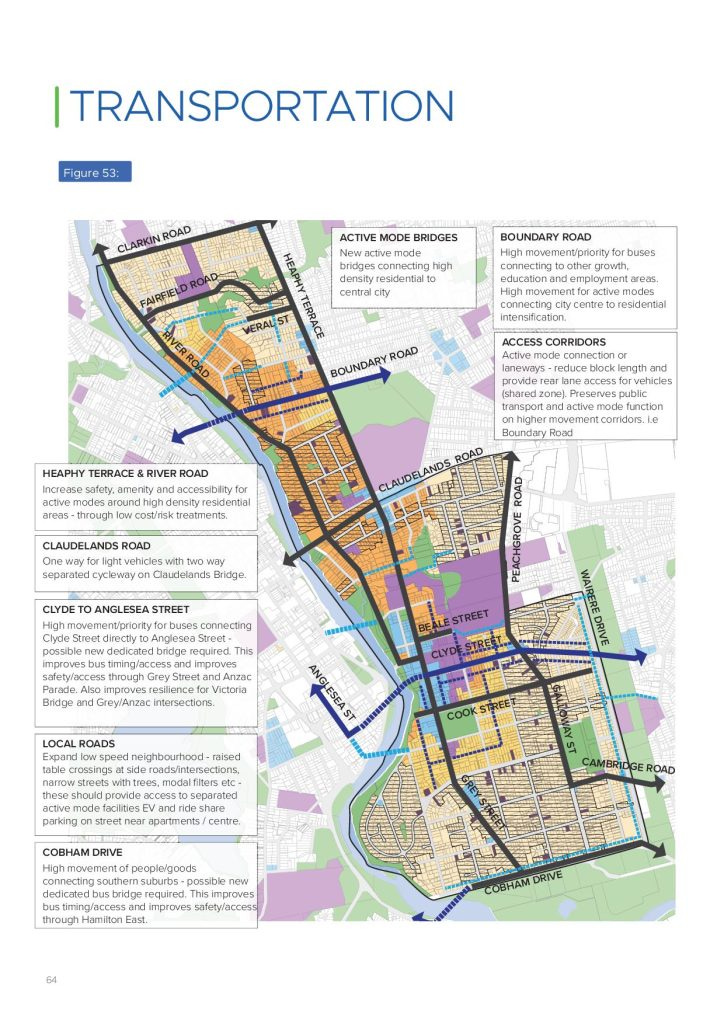
The latest plan is for a new bridge that links Clyde Street directly across the river to Anglesea Street over the top of Radnor Street. This can be seen in Plan change 12/Plan change documentation/Section-32 Appendix3.9 Eastern Hamilton Area Plan (page 65)

To add a more detail, the ‘high movement/priority [Bridge] for buses connecting Clyde Street directly to Anglesea Street - possible new dedicated bridge required. This improves bus timing/access and improves
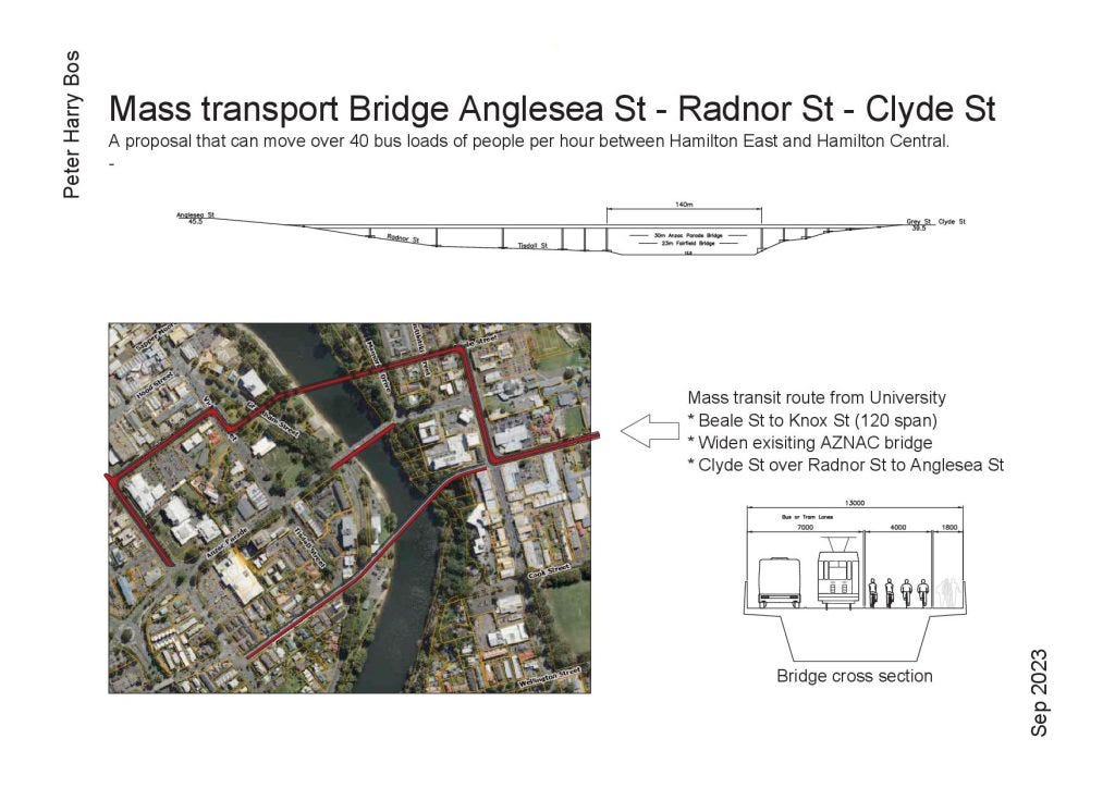
safety/access through Grey Street and Anzac Parade. Also improves resilience for Victoria Bridge and Grey/Anzac intersections’ (from above image). I have added a cross section image below to show the height above the river and give some idea of the effect on Radnor Street. Also shown is the proposal for linking Beale Street to Knox Street (link). Not shown, but worth a look, is ‘The Tronpier on the Tronway’.
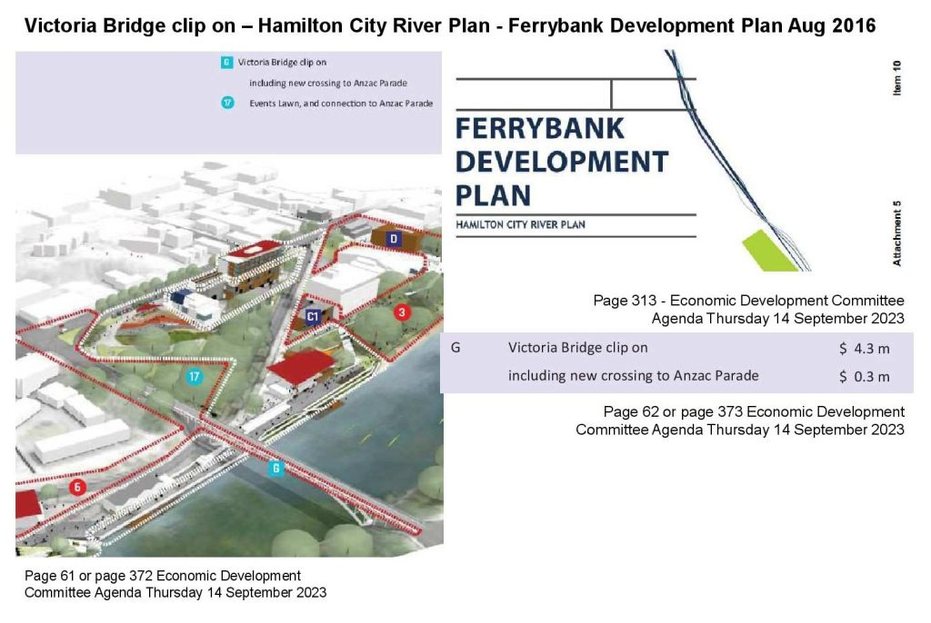
In 2016 funding for a ‘clip on’ to the Victoria Bridge was shown in the ‘Ferry Bank Development plan’, which should give space for separated protected bike lanes and a new footpath. However, there is a need for a full bus lane, and the most cost effective way of providing for all travel modes could be to add a third arch to the Victoria Bridge. (link)
Where there are ‘15 or more buses per hour on a route, special treatment for buses on this route should be considered ... In terms of the provision of bus lanes, it becomes increasingly justifiable as the number of buses increases to 20 or more buses per hour on a route during the peak, and most likely a necessity should there be 25 or more buses per hour.’ (AT p.15). The assumption is based on ‘a single lane carrying 900 vehicles/hour’. If these were all cars with an ‘average occupancy of 1.2 to 1.3 per vehicle’ (AT p.18) the lane would be moving 1,080 to 1,170 people at a speed of between ‘17-22 km/h’ (AT p.19). If this was a bus only lane of 20 buses per hour, each with ‘55 passengers’ (AT p.18), it would move 1,100 people at a speed of ‘>41km/h’ (AT p.19). Now is the time to start planning for a dedicated bus lane across the river, because within a few years the Anzac / Victoria Bridge bus route is very likely to have close to 20 buses per hour using it.
Further reference - ‘2010 Access Hamilton Passenger Transport Action Plan’ – Page 16 ‘Research suggests that for a bus lane to “break even” it requires 20 buses/hour, but the assessment depends on the level of congestion, the impact on other drivers, service patronage, delays avoided, etc.
Finally the Waikato Regional Public Transport Plan 2022-2032- Page 49 years 1-3 * Commence detailed planning for BRT corridor; Years 3-15 * Commence implementation of BRT corridors.


Thanks for commenting Alis, the best way to get change is to get to know local politicians as people, they are all good people. Where their ideas line up with yours, encourage them, their job can be a thankless one.
Both Bike Waikato - https://bikewaikato.org.nz/ & LivingStreets https://www.livingstreets.org.nz/ are active, you could start here.
Ka pai, this is awesome Peter. Just found the blog. Would love to get involved to help get Hamilton to be more walkable, cyclable, and with better public transport.