


Te Rapa Pa – my notes

I’ll start with the meeting house called Wairere (meaning flowing water). What we know is that “one of the Chiefs responsible for building the meeting house called Wairere at Te Rapa Pa” (p57*) was Porokoru, who was “one of the last chiefs to occupy Te Rapa Pa” (p56*) and another was Pirihi Tomonui (died 1891). “He was responsible for the dismantling of the large meeting house, named Wairere, which stood at Te Rapa Pa, now Cobham Drive” (p31*). What I would like to know is whether any of it survives as photographic records or as fragments of the original building. *Source: Wiremu Puke – Nga Tapuwae O Hotnmauea, April 2003
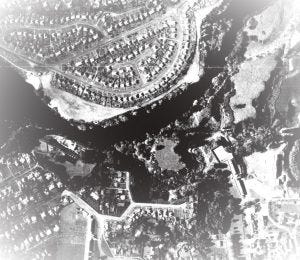
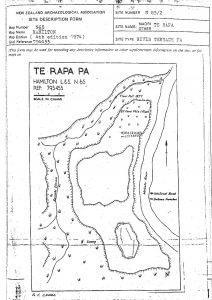
The location of Te Rapa Pa is south of the Kirikiriroa Pa, in the area now known as Graham Park, on Cobham Dr, and Yendall Park, which is near Waikato Hospital. The people living here were Ngati Koura and an early important resident was the warrior chief Hotumauea (a relative of Hanui) and later his descendent Parengaope (born 1765), who was the mother of the first Māori king.
Pre to 1863 European visitors to Te Rapa Pa** Benjamin Ashwell (Missionary), F.R. von Hochstetter (Geologist), Gorst and Fenton “Hochstetler drew a map showing a flour-mill, which was apparently located on the Kourahi stream. This was said to have been the mill with which Kirikiriroa was associated**” ** Source: Fiona Corcoran – Hamilton Library, Ref 993.115 1 VIS, 1998
I also have a scrap of paper titled ‘Hamilton historical sites – Early industrial sites’ which adds more detail about the flour mill.
“Te Rapa flour mill – This was situated near Te Rapa Pa and driven by the waters of the Kourahi stream, which were dammed up with an earth dam. Remains of this dam were visible before the site was destroyed by earthworks. This Kourahi stream is almost dry now as most of the run-off from surrounding area is carried away in storm water pipes. The mill was Maori owned and is shown on the map of the district drawn by Hochstetter in 1858”
More about the mill can be found in a book by H. Norris - Armed settlers: The story of the founding of Hamilton, NZ, 1864-1874 (page 17). "In 1857 Haera, a chief at Kirikiriroa, asked F.D. Fenton, the Resident Magistrate in the Waikato, to come to Kirikiriroa. This Fenton refused to do unless the Maoris there asked for him. However, he went to Te Rapa and spent the night, hoping that the invitation would arrive. It did not come, and he left. The feeling among the natives there, he thought, was not good. “Speaking of the mill here, which had broken and become useless, one said, ‘yes, the pakeha is a humbugging people’” (NZ Parliamentary Papers, 14 E No. 1 C.) The location of Te Rapa puzzled me. The name is now given to the district north of Hamilton, but in the survey at the time, the parish of Te Rapa is west and south of the original Hamilton West. A map provided by Gorst (J.E. Gorst: The Maori King) shows “Te Rapa or Kirikiriroa” on the west bank of the river. He seems to have considered that of the two villages encroaching on each other, Te Rapa was the more important. When he visited the Waikato a second time he said “The railway crosses the Waikato at the old ferry of Te Rapa, now called Hamilton” (J.E. Gorst: New Zealand Revisited). There is a natural pa, with the remains of food pits still showing, on the river bank between the pumping station and Waikato Hospital. This was probably the fortress for Te Rapa. Here, it is said, the Ngati Koura lived and one of them, Hotumane, was catapulted right across the river from a bent tree.” ( Waharoa Te Puke) Link to more on Maori flour mills of the Auckland Province 1846-1860 by R.P.Hargreaves
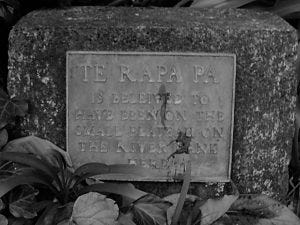
To conclude, at the end of Park Terrace is one of six plaques placed in the city of Hamilton in 1964. For more information, see the Waikato Times Hamilton Centenary issue, Monday, August 24, 1964: page 40 – Plaques mark historic sites.