


1919 NZ Planning Conference - the problem, the real problem, what planning can add and racism.

My notes on Germany 1648 to 1806 , Germany 1800 to 1840s , Waikato the golden age 1840s to 1850s , Waikato 1860s , Gentry & Speculators , The beginning of modern planning: Water, Sewage, Housing, Transport, City Centre, Markets and Zoning, 1890s: Introduction, Dwellings & Lots, Reason for Zoning, Horses, Cyclists & road deaths, York, City beautiful & genesis of motorways, Garden City, Dresden 1903, Chicago 1909, 1910s: Hamilton, Columbus, Rochester and Seattle, Newark, Berkeley, Bridgeport, Walpole, Genesis of housing crisis, Hamilton's 5 leg intersections,
The pages referenced are from the First New Zealand Town Planning Conference and Exhibition, Wellington, May 1919
The issues addressed are: 1a) NZ, an urban country; 1b) A real town planning problem; 1c) What planning can add; 1d) A racism problem; 2a) Garden suburbs; 2b) Planning rules; 2c) Example Kurralta Park; 3a) Root cause of problem; 3b) Cost of living; and 3c) Cost of home ownership.
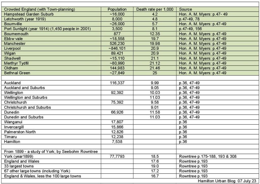
1a) From 1916 New Zealand had more people living in a Borough (p.34) [urban area] than in the Counties, and it was noticed ‘the increase in land-values caused by the growth of the cities is one of the primary causes of high rent. Next in importance comes the increase in the cost of building materials of all kinds, more particularly timber, plus the increase of the cost of labour caused by the higher standard of living of today as compared with past years’ (p.36). The concern was that New Zealand’s annual death rate per 1,000 persons (p.46) was double that of new ‘Garden Town Suburbs of England’ (p.46). A key point to note is that the demographics of a decade-old garden suburb are different to a half-century-old city, which is not explained at the 1919 conference. So below is a bit of a comparison.
1b) A real Town planning Problem – ‘One had only to bear in mind Christchurch, for instance, where a considerable part of the city was located in an area only 2 ft [0.6m] or 3 ft [0.9m] above high-water mark, and which was at one time a swamp. ... Then there was Balclutha. a town which was situated in a very dangerous position’ (p.179) ... ‘Napier was another instance where a considerable part of the town was built almost down to high-water mark ... Another town was Greymouth, the lower parts of which were inundated every time the Grey River was in high flood, with consequent extreme detriment to the health of the people’ (p.180).
1c) What planning can add – ‘The aim of town planning was to increase the amenities of a district affected by the plan, so that the people inhabiting the district might have the opportunity of a fuller and happier individual and social life. The economic effect of this fuller opportunity would express itself in the form of increased land values ... To be just and equitable it would have to provide that the increased land values created by the carrying-out of the scheme should be levied upon to pay or the cost incurred in carrying it out (p.91-92) ... the cost of town planning schemes should be paid for out of the increased land values the town planning created' (p.205).
1d) A racism problem – the Government Architect said, ‘A slum has been defined as a piece of land surrounded by Jews. Jews are sociable and gregarious; those who have seen the slums of East London and New York may appreciate this definition’ (p.216). Another speaker spoke about taxing ‘dogs and Chinamen because we did not want too many of them to be about’ (p92). In *Caroline Miller’s doctoral thesis Town Planning in New Zealand 1900-1933 she states - ‘This was not an isolated linking of planning with the need to produce a superior race ... there were links, through individuals with the more extreme views of the eugenics movement’ (p.275).